
Land usage footprint of Germany's food production
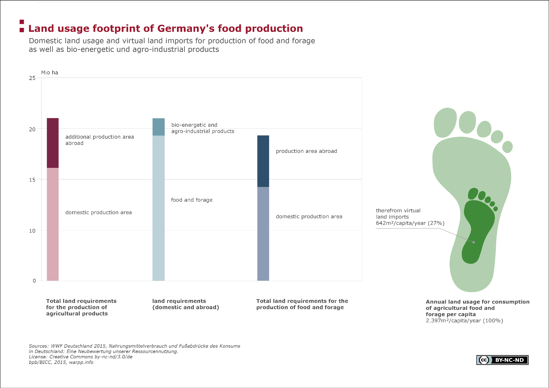
The diagram shows information on the actual area required for producing food as well as for products for bioenergy and the agro-industry in Germany. This allows the virtual footprint per capita for the consumption of agricultural food and animal feed to be calculated.
Facts
About 44 per cent (16.8 million ha) of Germany’s national territory is used for agricultural purposes, of which the largest portion (11.9 million ha) is used as arable land. According to a WWF study, a further 5.5 million ha abroad are also needed to cover the demand for agricultural products (food and feedstuffs as well as products for bioenergy and agro-industrial purposes) in Germany. Half of this extraterritorial area is located in South America, in particular in Argentina, Brazil and Paraguay. About one-tenth of the entire production area of 21.5 million ha is used for the production of food and animal feed and one-tenth for bioenergy and agro-industrial products. For the production of food and animal feed required for German consumption, three-quarters of the area used are domestic, and about one-quarter is abroad.
On the basis of the total area required, the per capita footprint for the consumption of agricultural food and feedstuffs can be calculated, which in Germany is 2.397m². It is notable that about 27 per cent of that are areas outside of Germany.
Terms, notes on methodology or reading aids
The virtual footprint describes the surface area required for the average consumption of agricultural food and animal feed.
Data sources:
WWF Founded in 1961, the WWF (World Wide Fund For Nature), located in Switzerland, is one of the largest internationally operating nature and environmental protection organizations Key topics, in addition to the conservation of biological diversity, include the sustainable use of natural resources and, as a result, the containment of environmental pollution and detrimental consumer behaviours. In relation to the latter topics, the German WWF section has published several studies in the last few years, which examine the consumption of food in Germany with regard to the exact area required at home and abroad.
Food consumption and footprint of consumption in Germany: A reassessment of our use of resources
https://www.wwf.de/fileadmin/fm-wwf/Publikationen-PDF/WWF_Studie_Nahrungsmittelverbrauch_und_Fussabduecke_des_Konsums_in_Deutschland.pdf
For a detailed overview of data and data sources, refer to Module “Environmental Safety”, map level “Land Grabbing”.
")
")
")