
Rise in sea levels
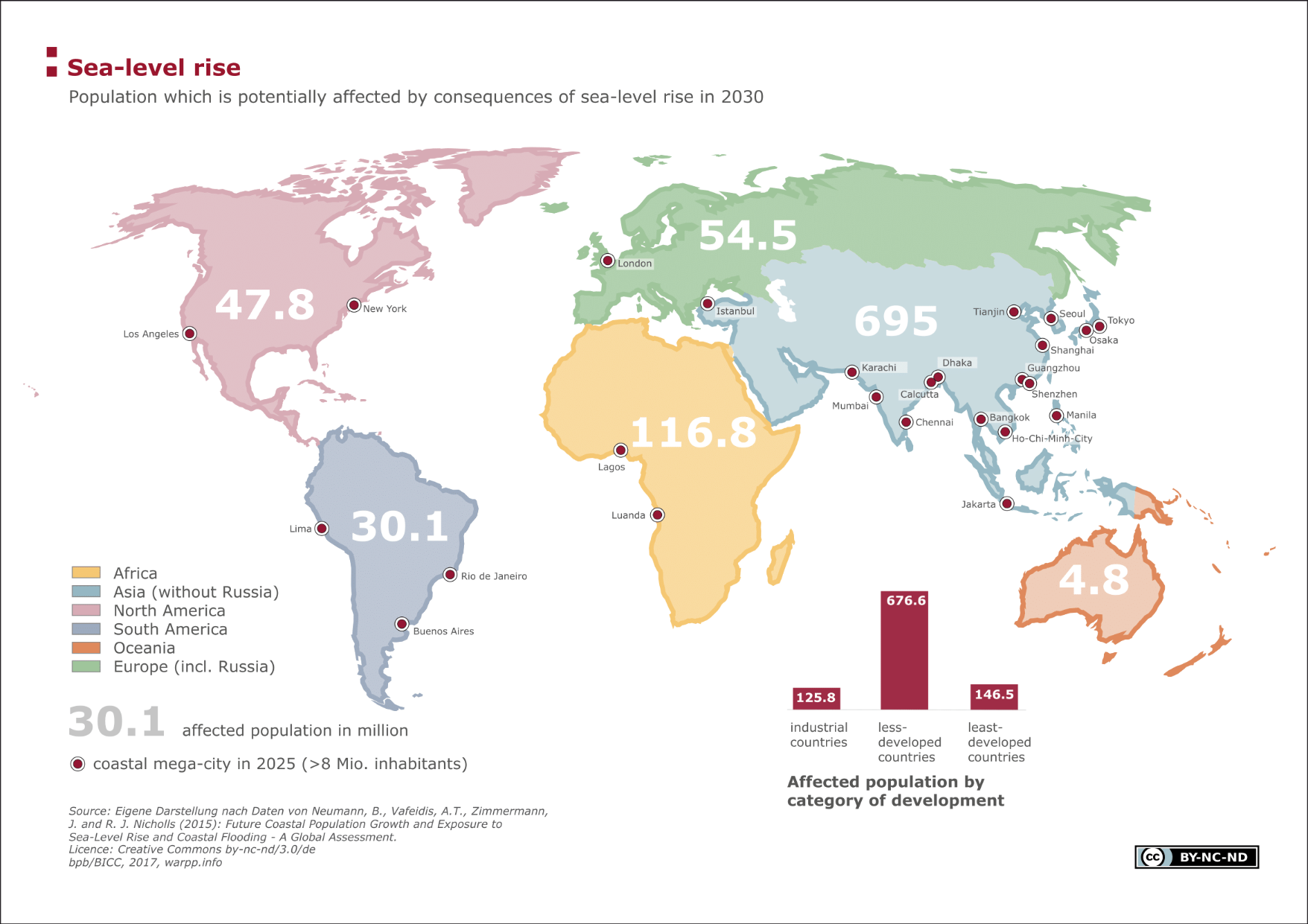
This chart shows the number of people on the different continents that will be particularly affected by the effects of rising sea levels in 2030. The forecast number of inhabitants by continent is presented here who will live in so-called low-elevation coastal zones (LECZ). The map shows megacities near the coast that, by the year 2025, will have more than eight million inhabitants. The bar chart compares the affected population of the three development categories—industrialized nation, less developed countries and least developed countries.
Facts
Based on the different urban and rural growth rates and an average population growth in the industrialized nations and high growth in the less developed countries, it is likely that 950 million people worldwide will live in low-elevation coastal zones. China, India, Bangladesh, Indonesia and Vietnam are already suffering greatly from the effects of the rise in sea levels today and will in future be most vulnerable. Added up, these countries represent more than half of the global LECZ population. Alongside Asian countries, African coastal nations show an increased vulnerability as here, too, a rising total population is forecast for the urban coastal areas. In Egypt, for instance, around 40 per cent of the population will live in the LECZ coastal regions in 2030 with the densely populated Nile Delta contributing significantly to this.
Calculations show that of the industrial nations the Netherlands will be the by far most affected country with 70 per cent of its total population (12.3 of 17.3 million). As concerns protective measures against storm tides and innovative adaptation strategies to the rising sea levels, the Netherlands are well ahead of many other countries
Terms, notes on methodology or reading aids
The low-elevation coastal zones LECZ describe flat coastal regions that are no higher than 0 to 10m above sea-level. This includes large river deltas and numerous small atolls and islands that are particularly vulnerable to the effects of rising sea levels.
There are different scientific studies on the global impacts of the rise in sea levels for coastal communities. While the study used here focuses on the different population growth in rural and urban coastal areas and does not take into account potential area variations until 2030 resulting from the rising sea levels, other studies take forecasts of the actual rise in sea levels and leave out future population growth. According to satellite measurements, the sea level rises by approx. 3.4mm every year; the Intergovernmental Panel on Climate Change even forecasts a rise of up to one metre in 2100. Even if the rise cannot exactly be predicted due to the many uncertainties, it is nonetheless probable that it will have severe consequences for ecosystems and inhabitants of coastal regions. On the one hand, among the consequences are coastal erosion, salinization of coastal waters and flooding; on the other the potential increase of devastating natural disasters such as, for example, tropical storms.
Data sources:
CRSLR (Coastal Risk and Sea-level Rise Research Group) The working group Coastal Risk and Sea Level Rise (CRSLR) of Kiel University’s Geographical Institute was founded in 2008 as part of the Research Cluster of Excellence “Future Ocean” and deals with the physical and socio-economic effects of the changing oceans as well as the effects of climate change on the earth’s coastal regions. Besides investigations into changes in land use in coastal areas or changes in wetlands close to the coast, the working group also looks at forecasts for coastal populations for the 21st century and the risks to them as a result of rising sea levels. CRSLR (Coastal Risk and Sea-level Rise Research Group) http://www.crslr.uni-kiel.de/de/
Neumann B, Vafeidis AT, Zimmermann J, Nicholls (2015). Future Coastal Population Growth and Exposure to Sea-Level Rise and Coastal Flooding - A Global Assessment. Online publication: 11/03/2015 http://journals.plos.org/plosone/article?id=10.1371/journal.pone.0118571
For a detailed overview of data and data sources, refer to module Environmental security, sub-category "Rising sea levels - affected population".
")
")
")