
Times of Peace 1946 to 2016
This information graphic provides information on the number of years a country has been at peace since 1946. For states that did not exist in 1946, the year of state formation is taken as base year.
Facts
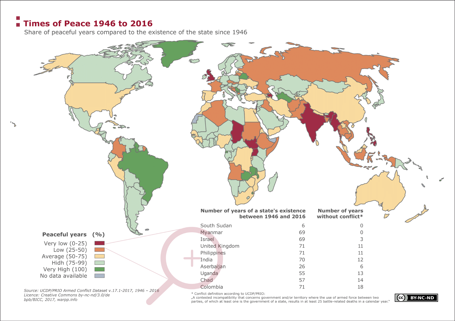
The years in which a country was not part of a conflict are counted as 'years of peace' (after World War II or state formation).For the Federal Republic of Germany, this means that, since its formation, it has experienced 52 years (of 68 years of existence) of peace. Compared globally, this is a long time. Switzerland, Belarus and the micro-states (that cannot be depicted due to scale) in Europe have, per definition, been experiencing total peace. Countries that have experienced total peace in Asia are the Central Asian countries of Turkmenistan and Kyrgyzstan, the Gulf states Kuwait and Qatar as well as Japan, Taiwan, Brunei and the Kingdom of Bhutan. While many countries in Latin America show a very high number of years of peace (as per definition), this only applies to every fifth country in Africa. During the time span in question, Angola, Ethiopia and Uganda were involved in conflicts for 80 per cent of the time, taking extra-state, interstate and domestic conflicts into account.
With 41 years, China has the largest share of years of peace of the five permanent members of the UN Security Council—an average compared globally. While the United States, France and Russia have a comparably low share of years of peace (25 to 50 per cent), Great Britain is even worse off with only nine years. Besides Great Britain for example Colombia, the Philippines, India, Myanmar, Ethiopia, Israel and the still very young country of South Sudan can be found in the category of 'very low' (less than 25 per cent of years of peace).
Terms, notes on methodology or reading aids
Years of peace are presented as a percentage of the total number of years and divided into five categories. When allocating the categories, participation in domestic wars and in wars outside of the country has been taken into account The number of participations in conflict is taken from the UCDP/PRIO Armed Conflict data set whereby only wars and conflicts were taken into account in which at least one state was involved and in which the number of casualties resulting from armed fighting was higher than 25. For the purpose of presentation, the number of years of conflict participation have been summed up and subtracted from the number of years under review (sum of total years minus sum of conflict participation).
Data sources
UCDP (Uppsala Conflict Data Program) and PRIO (Peace Research Institute Oslo) UCDP and PRIO publish the Armed Conflict Dataset and the Battle-Related Deaths Dataset on an annual basis. These were combined to localize wars and conflicts. The definition of war the dataset is based on only considers wars or conflicts with the participation of at least one state and in which more than 25 persons have died as a result of armed fighting Wars were grouped according to extra-state / extra-systemic violent conflicts (state against a non-state actor outside of existing borders), interstate wars (between two states), intra-state (state against a non-state actor within existing borders) and internationalized intra-state conflicts (state with the help of other states against a non-state actor within existing borders).
UCDP (Uppsala Conflict Data Program)- Armed Conflict Dataset
UCDP (Uppsala Conflict Data Program)- Battle-Related Deaths Dataset
PRIO (Peace Research Institute Oslo)- Armed Conflict Dataset
PRIO (Peace Research Institute Oslo)- Battle-Related Deaths Dataset
")
")
")