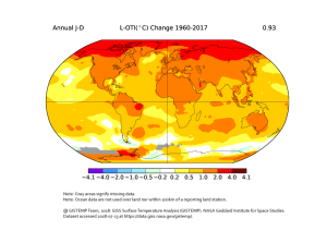
This map layer shows the temperature trend by country between 1960 and 2017.
The rise in the average ground temperature as a result of increased greenhouse gas emissions since industrialisation is called global warming. The Fifth Assessment Report of the Intergovernmental Panel on Climate Change (IPCC) shows that the surface temperatures of the last three decades were, one and all, warmer than all the previous decades together since 1850. While only isolated measuring stations could be found before the 19th century, this changed rapidly at the start of the 20th century. Since 1960, at least 80 per cent of the northern and southern hemispheres have been covered. Globally, only a few data sets on global temperature changes exist, as the combination of historical and modern measurements has proven to be extremely complex. While data sources and methods of various data sets differ, the value for the average global temperature change calculated is similar, at 0.85 degrees Celsius (1880–2015).
On the basis of the Global Historical Climatology Network (GHCN), which collects the monthly average temperature values from over 7,000 measuring stations worldwide, as well as other data sets on sea surface temperature, the NASA-affiliated Goddard Institute for Space Studies (GISS) produces global temperature analyses for the period 1880 till today. It should be noted that the temperature changes shown on the map have been averaged by country—the original map which is linked as an information graphic (see below) shows that considerable regional differences within a country can indeed occur. Furthermore, it should be noted that the temperature information from global temperature datasets could deviate from measurements taken at the national level.


